If you lived in tornado alley for more than one storm season, you’ve been there. The meteorologist spends three days warning about a potentially historic tornado outbreak. Then that day comes and goes with nothing but clouds and a little rain. The comments section in your local meteorologist’s page fills up with all the name-calling and arm-chair meteorology feedback. Lied again. Just scaring us for the ratings.
Another storm is on the horizon and the ingredients start to line up, but this time the meteorologist holds back. They don’t want to get those same accusations. The day of, a tornado drops out of a storm that had no warning. People are angry about that too.
I get that it can be frustrating, especially when you see it play out year after year. Our weather is crazy and sometimes we even make plans around it, so it would be good to have reliable forecasts. While people think it might be easy, our meteorologists have a tough job. They are trying to predict where a pocket of air will be days in the future and making the best call they can with information that they have. I want to show you what that actually looks like, because once you see it, I think you’ll cut them a lot more slack.
Full disclosure: I’m not a meteorologist. I’m just a weather nerd and data analyst who has lived in tornado-prone areas my entire life. I used to be terrified of storms, but that has also led to my fascination with them. And I mean I am a nerd about it. Like I watched The Weather Channel as a kid. Twister is still one of my favorite movies. In another life, I may have even pursued the meteorology route, but the calculus scared me away.
In my actual profession, I look at competing statistical models and vast amounts of data. I have to communicate uncertainty to people who just want a clear answer, so I can relate to how these meteorologists often feel. The right things have to come together in just the right way days from now, and though they have models and modern instruments that provide them some insight, it still can be tricky.
The Recipe
Meteorologists often communicate severe weather in terms of “ingredients” to help us understand. To get significant tornadoes, you generally need several things to come together at the same time and place: instability (the atmosphere’s potential energy, often measured as CAPE), wind shear (winds changing speed and direction with height, which gives supercells their rotation), and moisture (that thick, humid air we know so well by May).
However, just because you have the ingredients, doesn’t necessarily mean the show happens. I can’t just plop flour, eggs, butter, and sugar on my counter and expect a cake to magically form. Something still has to bring those ingredients together in the right way at the right time. In places like Oklahoma, that “something” is often the most unpredictable part of the equation.
When your meteorologist says “the ingredients are there,” they mean the flour and eggs are on the counter. What they don’t yet know is whether the oven is going to turn on.
The Oven
So what turns the oven on? Meteorologists call it forcing: the dynamic mechanisms that actually lift air parcels from the surface up through the cap and into free convection. Having all the ingredients is one thing. Forcing is what pulls the trigger.
There are a few common culprits in Oklahoma. A big one is the dryline: the boundary between the moist Gulf air pushing in from the east and the hot, dry air rolling off the high plains to the west. Where those two air masses collide, air converges and has nowhere to go but up. However, the position of the dryline matters enormously. Too far west and it never interacts with the richest instability. Surging too far east too fast and it can actually undercut the moisture it needs. Another is the upper level jet, which pulls air upward from below. If that support is centered over Kansas rather than Oklahoma, storms may fire hundreds of miles north of a perfectly loaded Oklahoma environment. Third, outflow boundaries from previous storms, sometimes invisible on a surface map but visible on radar, can also serve as a local trigger when nothing else will.
The frustrating reality is that you can have a textbook ingredient environment in Oklahoma and still get nothing because the oven never turned on. Meanwhile, Kansas gets the outbreak. The ingredients and the forcing have to overlap, and that overlap can be razor thin.
The Models
To forecast severe weather, meteorologists rely heavily on prediction models. I imagine that, much like I have SAS to run complex statistical analyses for me, meteorologists have computer models to run complex mathematical simulations of the atmosphere instead of doing the calculus by hand. Those of us in tornado alley may have heard our meteorologists mention some of them: the GFS (American model), the NAM, the HRRR, or the European model (ECMWF).
However, the models aren’t perfect. They are also operating under different assumptions, different resolutions, and different ways of handling small-scale atmospheric processes. Because the atmosphere is a chaotic system, small differences in those assumptions can produce dramatically different solutions, especially several days out.
Let me show you a real example from this week.
Below are two model soundings for roughly the same spot and time in southwest Oklahoma, valid for Thursday evening, April 23rd. A sounding is essentially a vertical profile of the atmosphere. Think of it as a slice from the ground up into the sky, showing temperature, moisture, and wind at every level. Meteorologists use them to assess how favorable the environment will be for severe storm development at a specific place and time. One is from the NAM model. One is from the GFS.
NAM Sounding:
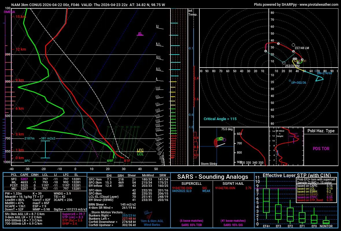
The NAM sounding, which I originally found on Twitter, is painting an extraordinarily dangerous picture. Surface-based CAPE of over 5,000 J/kg is an absurd amount of atmospheric energy. Effective storm-relative helicity of 381 m²/s² favors intense, rotating supercells. The composite indices are off the charts. And the hazard flag in the bottom right? PDS TOR = Particularly Dangerous Situation, Tornado.
GFS Sounding:
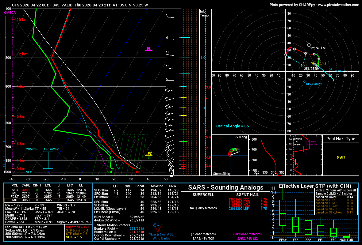
The GFS tells a completely different story. For roughly the same location and time, this sounding says SVR, which means severe storms. Effective helicity less than half of the NAM’s. CAPE values nearly 2,000 J/kg lower. The atmosphere is quite a bit less favorable for tornadoes. Critically, the GFS run shows a cap, while the NAM shows none.
The Cap
About the cap… that’s another key thing in whether we get the breakout event or nothing. Those of us in Oklahoma have heard our meteorologists talk about it, but what is it?
The cap is a layer of warm air in the lower atmosphere that acts like a lid on a pot. It suppresses storm development. Severe storms are like the sourdough bread of weather. They need to rise a LOT. If the parcels of air rising from the surface hit that warm layer (cap) and get pushed back down, it stops them from developing into severe thunderstorms. A strong cap on a volatile day can mean the difference between a historic tornado outbreak and a completely quiet afternoon.
The cap is also enormously sensitive to small differences in the atmospheric setup: a dryline that sets up 30 miles to the east or west, a low-level jet that arrives two hours early, the exact temperature of the air at 850 millibars. These are things that models handle differently, and that’s why the GFS can show a strong cap while the NAM shows none for the exact same place and time.
If the cap holds too long, storms fire late, lose daytime energy, and underperform. If the cap erodes too fast or too broadly, storms fire everywhere at once and the tornado threat is actually reduced. If the cap erodes in just the right place at just the right time, you get discrete supercells in a maximally dangerous environment. It’s like the Three Little Bears. Tornadoes need the cap to erode just right.
Your meteorologist knows all three of these scenarios are on the table.
The Forecast
Now imagine you’re a meteorologist in Oklahoma City on a Tuesday, looking at a Sunday setup. You pull up the NAM and it shows a PDS tornado environment. You pull up the GFS and it shows the cap holding and no tornado threat at all. The European model is somewhere in between.
You know that if Sunday verifies closer to the NAM solution, and you didn’t warn people, you will have failed at the most important part of your job: protecting the public. You also know that if Sunday verifies closer to the GFS solution, and you spent all week warning people about a potentially historic outbreak, the comments section is going to light up… again. You’re torn between not warning people about something historic or being accused of crying wolf.
Four or five days out, the models are fighting with each other and the forecast is legitimately uncertain. This is when you’ll hear your meteorologist say things like “potential” or “conditional.” As the day gets closer, usually model runs start trending toward agreement, or the disagreement sharpens in meaningful ways. They can also start looking at short-range models like the HRRR to help with their forecast. Additionally, weather balloons, launched twice daily from sites across the country, give forecasters actual real-world data about what the atmosphere looks like right now. By Sunday morning, your meteorologist will know a lot more than they did on Tuesday. The language will get more specific and the uncertainty will narrow.
The next time a forecast doesn’t pan out the way the models suggested it might, try to resist the urge to criticize your meteorologist. Yes, sometimes there is over-hype, but I truly believe (at least with our local meteorologists) that’s the exception, not the rule. They were looking at multiple models saying completely different things four days out, making an educated call about on whether they should communicate that risk, and hoping the atmosphere will cooperate.
Sometimes it does. Sometimes it doesn’t. Mother Nature does her own thing, especially in tornado alley.

Leave a comment